
 L Lemo-Opuscar
卫星地图简报
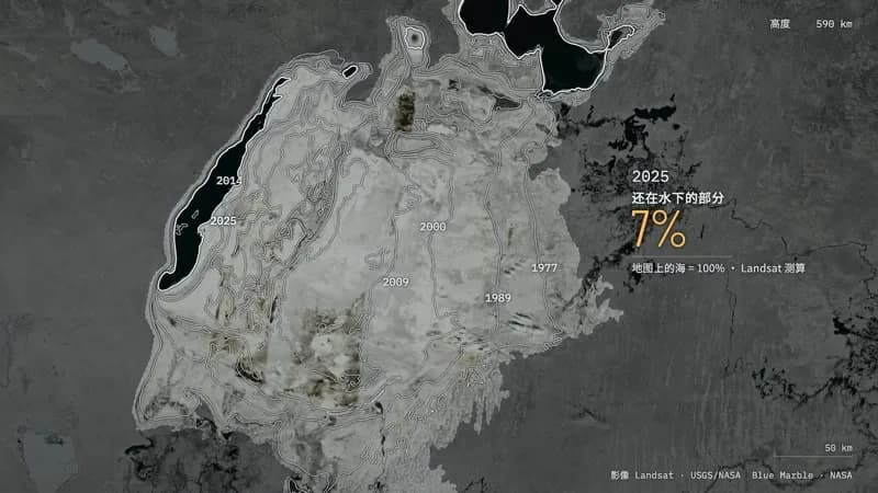
卫星照着地图去找咸海,找到的是沙漠;只有筑了坝的那一块回来了。
- 适合:
- 讲地点、范围
- 系列:
- L Lemo-Opuscar
- 更新:
- 2026-10-29
风格提示词
Satellite Briefing — Style Prompt
Real satellite imagery of a real place, graded down to an analyst's grey, with thin white measurement lines drawn on the ground: a lock-on reticle, outlines, a range line, one reading. One continuous zoom built from stacked imagery plates carries the viewer from orbit to the ground and back, and time can run inside one locked frame.
References (grammar only): open-source investigation films that annotate satellite pictures (thin lines on imagery, one claim per screen, measuring as the plot); the Eameses' Powers of Ten (one continuous change of scale with a readout); NASA Earth Observatory's World of Change (one place, time running). Copy none of their layouts, typefaces, icons or music; never name them in the film.
1. Essence, and what it is not
- The ground is a photograph: real, licence-clean, georeferenced satellite or aerial imagery of the actual place. Nothing on the ground is drawn, stylised or generated.
- Two layers, two truths: the imagery is what the satellite saw; the hairlines are what the analyst measured. Marks are thin, white, sparse, and sit on real coordinates.
- The grade moves with the story: orbit in true colour, the analysis layer in grey, colour back only where the story turns.
- Scale is the camera: one zoom from orbit to the ground built from nested plates, with an altitude readout and a scale bar from the same camera.
- One finding per screen, in the single accent colour.
Not Data Storytelling (a chart on paper), not Sci-fi Hologram HUD (no glowing wireframes or invented chrome), not Blueprint, not Isometric Infographic (real nadir or oblique views, no diorama), not a keynote (no slides, header bars or chapter numbers).
2. Materials & rendering
- Plates: georeferenced rasters with a lon/lat box, sampled in a shader where the camera ray hits the ground, nested by resolution (world → region → detail) with feathered edges so finer plates dissolve in as the camera descends.
- Globe: ray–sphere from a perspective camera, a thin atmosphere rim, limb shading at orbit only; compute |C|² − R² in double precision (float32 fails below a few tens of km).
- Time: dated plates share one grid. A soft scan front (a satellite pass, never a hairline) swaps them: north → south forward, south → north for a rewind. Growth can run outward from the old edge, ordered by a distance map.
- The analyst's grade (one uniform from colour to grey): luminance with local contrast and clarity, a shoulder so salt, snow and cloud stay below white, toned blue-black → cool silver up to ~65 % grey, a fifth of the chroma. White belongs to the marks.
- Marks: a 2D overlay through the same world → screen function: hairlines 1.2–2.6 px with a dark halo, dashes for history and claims, brackets, ticks, leader lines. Lines draw on; outlines print behind the scan.
- Screen space only for instruments (altitude, scale bar, imagery credit) and the transcript strip. Everything else is anchored to the ground.
- The claim layer is a printed map drawn in the shader from a distance field of the old outline: paper grain a few pixels wide at any zoom, halftone ink, coast and waterlines, graticule, the serif name.
- Post: light grain in ffmpeg, a vignette, directional blur only on whip pans.
3. Colour logic
- Neutral ground: grey, roughly 3–65 % in value. White means measured.
- One accent (warm, e.g. amber) for the single reading on screen, never decoration.
- A second hue may mark the claim the imagery tests (a map, a plan, a promise): flat, cartographic, never used for anything measured.
- True colour is evidence: at orbit, and again only where the story turns (the field that greened, the water that returned).
- No false-colour ramps over the imagery.
Example (our demo): ground #070B0E → #A1A7A9, marks #F2F5F6, reading #FFBE55, map blue rgb(46, 112, 206).
4. Type & subtitles
- Roles: a light condensed grotesk for the reading (96–130 px, e.g. Barlow Condensed); a monospace for instruments and dates (20–34 px, e.g. IBM Plex Mono); a sans for labels in the film's language (24–42 px); a serif only for the claim layer and the title. OFL, self-hosted, CJK subset to the characters used.
- Labels attach to the ground with a leader line. The reading sits in the right third beside what it measures, label above, source note below ("Landsat, measured").
- Subtitles are a transcript strip at the bottom left: a 2 px white rule, a dark plate fading right, left-aligned, each line on one line (measure with the real font,
nowrap; split a long sentence into two cues). If the film is bilingual, the film's language on top. - Nothing below 20 px at 1080p, the imagery credit included.
- Hold subtitles ≥ max(1.8 s, speech + 0.6 s); a rolling counter reports its landing value; labels stay ≥ characters ÷ 4.5 + 1.5 s (CJK).
5. Motion quality
- The camera never stops: distance interpolates in log space, segments ease, holds keep a 2–5 % creep or a slow rotation. No frozen frame longer than a second.
- Marks arrive by being made: a line grows, an outline prints behind the scan, a counter rolls and lands with a small pop, a reticle snaps with overshoot.
- Time changes are scans, never dissolves; their spacing tells the speed, and the camera moves with them (accelerating as the steps shorten, braking on the last).
- Never moves: the ground under its annotations, the instrument positions.
6. Camera grammar
| Move | What it expresses | Can serve |
|---|---|---|
| Oblique orbit, limb in frame | scale, context, distance | an opening; a return; a title card |
| Dive (log zoom, tilt to nadir) | going to look for yourself | a reveal; checking a claim |
| Locked nadir frame, slow creep | evidence, comparison | time running in one place; a measurement |
| Push-in on a point | singling out | one town, one dam, one field |
| Track along a line | travelling a distance | measuring; a river, a road, a border |
| Whip pan with blur | a new subject at the same altitude | the counter-example; "meanwhile" |
| Climb back to orbit | consequence, perspective | an ending; a summary |
At key moments the subject fills a third of the frame height; reading right, subtitles bottom left, instruments in the corners. Transitions: scan-line swaps, a map layer switched off, zooming through plates, whip pans, the reticle opening into a title card. No crossfades between unrelated places, no hard cuts inside a zoom.
7. Sound palette
- Telemetry: FM pings (a lock-on ping worth bringing back), dry ticks on the grid that divide to accelerate, noise scans (rising for a rewind, falling forward), servo whines, a ratchet for a range line.
- Weight: timpani, bass drum, gran cassa, bowed cymbal, a tam-tam reversed when time runs backwards. Measurements land on a pitched hit.
- Synthesis: a pulse bass with audible 2nd and 3rd harmonics, detuned-saw pads under a low-pass, risers for dives.
- Beds: orbit hum, radio hiss, data chatter; the place's own ambience (wind, water, a far horn), sparingly, often as J- or L-cuts.
- One option for the shape: keep the palette dry (electronics, skins, metal) and let one wet timbre (glass, water, bowed metal) mark the turn.
- Silence: music and foley stop, a thin bed stays, impacts may decay into it; the first sound after it is the turn. A short suck-out (0.2–0.45 s, music and foley down ~25 dB) before the heaviest impacts makes them land.
- Mix: voice ~10 dB over music; the two or three designed impacts are the loudest moments (out of the bus compressor, with mid-range body, e.g. a low-brass stab); 20–60 Hz about 15 dB under the full band (high-pass ~40 Hz, impact weight at 60–120 Hz); −14 LUFS, true peak ≤ −1.2 dB. Voice: a calm analyst, short declarative lines.
8. Native moves
- The map against the photograph. The camera falls into the printed map of the claim; a scanner bar tears it away and the ground is underneath; the name outlives the page. Fits content like: a lake still on maps but gone; a cleared concession forest; a planned city never built.
- Time rings in a locked frame. Dated plates scan in one by one; each leaves its outline, the band lost between two rings flashes. Fits content like: a glacier's retreat; a city's sprawl; a fire scar season after season.
- The range line. Mark the destination, grow a ticked line from A to B, chase the tip while the reading counts up, land on the number, pull back to show the whole distance. Fits content like: how far a shore moved; a village to its well; a camp to the border.
- The dive and the climb. One zoom from orbit to the ground, or back. Fits content like: locating anything; a scale reveal; an ending that returns one place to the planet.
- Colour returns where the story turns. Only the subject regains true colour inside the grey. Fits content like: an irrigated field; a refilled reservoir; a regrown forest.
- The reticle becomes the frame: the lock-on brackets open out to frame a title card or the last reading.
9. Pitfalls of the medium
- Licences: not usable: Google Earth/Maps, Bing, Esri World Imagery, Mapbox Satellite, Planet, Maxar, news photos, AI-generated imagery. EOX Sentinel-2 cloudless is CC BY 4.0 only for 2016 (2018 onward is NC). Raw Copernicus Sentinel data need "Contains modified Copernicus Sentinel data [year]"; check the user's rules. Public domain or free with credit: USGS Landsat (1972 on, worldwide), USGS NAIP (US, ~1 m), NASA Blue Marble, MODIS, VIIRS. Burn a readable credit into the picture and list every asset in
CREDITS. - Finding imagery for a new place: search by bounding box and date in the Planetary Computer STAC (Landsat C2, Sentinel-2 L2A; no account) or USGS EarthExplorer; MODIS/VIIRS and Blue Marble from NASA GIBS; outlines from Natural Earth. Log every request. OSM (ODbL), CC BY-SA and "no known restrictions" are not CC0: name the terms and ask the user first. Ask for the user's own surveys or GIS layers when the place is theirs. Never fill a gap with generated imagery presented as evidence.
- Seams: paths imaged on other days disagree. One date per path, each scene gain-matched on stable land, feathered overlaps, holes filled from the same year only.
- Old sensors: Landsat MSS (to 1992) has no blue or SWIR and drops scan lines: nearest-neighbour resampling, near-zero rows as nodata filled from same-year scenes, scan-angle streaks cleaned on land only. Inspect every year at full contrast.
- Plumes and haze cross water as bright diagonal bands: swap the scene for another date of the same year rather than painting it out.
- Edges: resampling against nodata darkens scene rims (erode the mask); drop contour pieces along a plate border. Real straight edges (dikes, polders) can read as seams: frame them out or label them.
- Grey mush at close range: raise local contrast for that altitude only and dim outside the measured corridor.
- Water and cloud: MNDWI where shortwave infrared exists, only the basin you measure; clouds read as features in grey, so use the dry season.
- Facts: keep a FACTS.md in the project folder (claim, source URL, quoted wording, or the measurement method with scene IDs and dates) and deliver it with the film. Measure on the date you show.
10. Engine
demo/engine.js:makeCamera({lat, lon, d, tilt, heading, sx, sy}),project()/unproject(), the WebGL2 plate shader (nested plates, time scans, growth map, analyst grade, printed-map layer, whip blur).demo/overlay.js: hairlines, brackets,readout, the measured single-linesubtitlestrip,textwith a registry forwindow.TEXTS.demo/tools/:fetch_landsat.py(STAC, one date per path, same-year gap fill),plates.py(normalisation, streak cleaning, water masks, areas),vectors.py(shorelines, distances),mapfield.py(the printed map),growth.py.- Extra packages and packs: none beyond
setup.sh deps voiceand the sample packs the score uses (sh tools/fetch.sh instruments <lib>for vsco2ce, vcsl, freepats in the demo). Imagery uses only the standard library, numpy, SciPy, Pillow (no GDAL); allow 3–4 GB for cached scenes. Anything more (rasterio, pyproj) goes in a private venv in the project folder, not$LIB/.venv.
11. Variation space
The agent decides the place or places, whether there is a claim layer, which dates, the structure, the camera path, the accent hue and where colour comes back.
- Structures: a locked time-lapse of one place ending in a push-in; a river followed from source to mouth with a reading at each stop; two places compared at one scale with whip pans.
- Openings: a ground-level detail that climbs to reveal its scale; a black frame a scan line paints in; an oblique orbit with a searching reticle.
- Endings: the climb back to orbit; a last measurement that lands and holds in silence; the claim layer redrawn to match the ground.
How our demo was made (story, shots, score, end card, build): DEMO.md. Read it after your treatment exists.
补充
示范片
The Map Still Says Sea
本风格的来源项目:开源项目 Lemo-Opuscar(项目仓库)。本站保留原项目署名,具体许可以该项目仓库为准。
分享来源:B 站视频(341 种代码动画风格)